THE MARITIMES SCANNING SITE
AERONAUTICAL SCANNING
SPECIFICS FOR CANADA’S MARITIME PROVINCES
Last updated
February 11, 2010
For current aerodrome (airport) charts for any significant field
in Canada go to this Nav Canada
link
PLEASE NOTE THAT SOME PARTS OF THIS PAGE ARE BEING TRANSFERRED TO OTHER, SMALLER PAGES BUT PERHAPS WITH EXPANDED EXPLANATIONS. FOR THE TIME BEING EVEN IF A NEW PAGE HAS BEEN CREATED THERE MAY BE SOME SECTIONS STILL HERE THAT WILL BE LATER TAKEN OUT.
This page is targets scanner listeners who might be interested in listening to aircraft. In listening on the aero bands there is a lot to learn about how it all works, so I will attempt to describe the current situation in our area, including the basics of aircraft movements and the associated radio traffic. I am no expert in the subject and am not a pilot, though I would love to be one! but I have listened to aero communications for many many years, and have a pretty fair interest in aircraft themselves. Because I live in the Halifax area my detailed commentary is about my own area, but the principles and procedures are similar elsewhere.
The Maritimes lie in
an area that is particularly rich in aero signals. Most of the traffic between
Europe and the northeast and Midwest USA flies over the region, and by all
accounts this is the busiest long-haul route in the world. There is an
endless, but not necessarily consistent, stream of airliners, military aircraft,
executive planes and cargo jets passing overhead. A sad reminder of this
traffic is the 1998 crash of Swissair’s Flight 111 near Peggy’s Cove, about 50
km (30 miles) from my location, and the diversion of near 40 flights to Halifax
on September 11, 2001 when air traffic in North America was shut down.
In addition to this
high-flying traffic there is a respectable amount of traffic in and out of the
airports of this region, the busiest being Halifax Stanfield International
Airport. This airport was named recently for Robert L Stanfield, a former
premier of Nova Scotia. I live about 20 miles from Halifax International and
under the approach path for Runway 05* (departure for 23) and have a daily view
of low-flying aircraft passing overhead. In the winter of 2009/10 I
have been commuting daily beside the Halifax airport and have the scanner on as
I pass. Also in the Halifax area is a lightly
used military airfield, Shearwater. There is always something happening on Aero
VHF! *normal Canadian usage is to always use two
digits for runway designations. American pilots would refer to this runway as
5.
I have included on
the site a list of call signs used by various airlines and military units here
in the Maritimes. For example, if you hear Speedair 214, this list will tell
you that this is an aircraft from Provincial Airlines. The list includes only
traffic normally using the airports in the region, not those simply passing over
at 35,000 feet.
CONTROLLED AIRSPACE IN THE MARITIMES
Other than military
zones, Canadian airspace is managed by Nav Canada, a corporation owned jointly
by the federal government and the aero industry. All area control centres and
flight service stations are owned and operated by Nav Canada as are almost all
towers and terminal control units. Air Traffic Control is divided into two main
categories: Airport and surrounding area, and enroute airways control.
1) Airport and surrounding areas:
Most airports are
uncontrolled, but even if so they all have at least one frequency used for
cooperation amongst pilots in determining their own safety, or for advisory (not
control) communications with personnel on the ground. Effective December 2009
there are five
airports in the Maritimes with control towers: Halifax, Moncton, Fredericton
(0800-1600 local time), Shearwater
(military, part-time), and Greenwood (military). Each of these has its
accompanying control zone. Halifax and Greenwood also have an extended
area of control, the terminal area (which has nothing to do with the airport
building of the same name). The Greenwood military terminal control unit
(TCU) operates 24 hrs daily. Personnel for the Halifax TCU are
co-located with the Area Control Centre near Moncton. The Halifax TCU operates
most of the day but at night, in the quiet hours, it shuts down and the
area
comes under direct control of Moncton Centre Low Level (see below).
All airports with
towers also have an associated Ground Control frequency.
2) Enroute airways control:
LOW LEVEL: The low
level airspace in the Maritimes is controlled from the Area Control Centre near
Moncton, New Brunswick. Although the low-level frequencies are shown on the
list below you may find it more beneficial to see the map that also shows the
three terminal areas mentioned above
HIGH LEVEL: The high
level airspace (about 20,000 feet and up) is almost completely under the control
of Moncton Centre. The high level map shows the previous situation in which
Gander Centre controlled the eastern part; however the frequencies are
unchanged. Small areas of western and northern New Brunswick are controlled by
Boston Center* or Montreal Centre. Frequencies for adjacent parts of
surrounding centres are shown on the maps and in the frequency list
*
American spelling. In Canada the official spelling is “centre”.
This list is perhaps the most
extensive one you will see for
the Maritimes as it includes frequencies for even the smallest airfields in our
region. It also includes often-heard frequencies from surrounding areas. The
only thing I have knowingly not included is the company frequencies of the
overflying long-distance airliners, which in most cases would be using the ARINC
VHF air/ground frequencies or the HF LDOC frequencies (which are not part of
scanning).
Items marked “ATC” imply Air Traffic Control and include ground control, towers, terminal control, area control and less rigorous controls such as traffic frequencies and flight service stations, many of which are used to pass airport information to aircraft.. “Private Services” indicate frequencies used for traffic to and from private concerns such as airlines, ARINC and general aviation service providers.
One of the key pieces of information you need to know is that only Shearwater, Halifax, Greenwood, Moncton and Fredericton have control towers, and some of these are only part time. This means that in reading my descriptions of air traffic and communications, things will be much simpler at all the other airfields, the ones that do not have towers. At those other fields the pilot makes their own decisiions about landing and taking off, and you will not hear near as much radio traffic. If there is no tower there is no ground control, and if a field is not busy enough for a tower it is likely not to have much in the way of company specific traffic either.
-----------------------------------------------------------------------------------------------
SUMMARY OF ACTIVITY IN THE HALIFAX AREA
This summary excludes
high-flying overflights. Aero traffic in the Halifax area is made up mostly of:
1. Airline and cargo flights in and out of Halifax International Airport.
2 Daytime military helicopter training flights in and out of Shearwater.
As far as radio and scanning is concerned here is a description of activity.
AIRPORT AND LOCATION DESIGNATORS
It might be worthwhile to mention these designators before I go on.
4 - LETTER ICAO
All licenced airports in the world have a designator that is unique. Those that are larger or have some kind of special significance will have a 4 letter designator issued by the ICAO (International Civil Aviation Organization). The first letter indicates the region of the world, and some countries get their own. American ones start with K and Canadian with C. The second letter for Canadian fields is almost always a Y but a few have W and there are a very few odd ones with other "second letters". The third and fourth letters are assigned by the country itself and may or may not be associated in some discernible way with the airport itself. For example Vancouver Airport has CYVR and we can all see that VR goes with Vancouver and Nanaimo Airport on Vancouver Island receiving CYCD goes with its location in the community of Cassidy, and CYSJ fits very well with Saint John. The vast majority have lesser significance if any and this is true for Shearwater (CYAW) and Halifax (CYHZ) and Toronto (CYYZ). Small airports might be "lucky" enough to get one of these international designators but most have a national one made up here in Canada of 3 letters followed by a number e.g. CAT4 or CBF7
3 - LETTER IATA
The International Air Transport Association is the world-wide industry organization. One of the things it does is assign 3 - letter designators to airports that receive cargo or passenger service. These are the familiar codes one sees on baggage tags. Here in Canada and in the United States, these are almost always (but not quite entirely) the same as the ICAO 4 - letter designators minus the first letter. Thus Halifax is YHZ and Vancouver is YVR. Occasionally there are small airports that don't have an ICAO code that nevertheless have scheduled air service and therefore need an IATA code so one is made up for it. For example the CAT4 mentioned previously has been given XQU by the IATA.
Generally speaking the 3-letters used for American airports and for many large international ones make a lot of sense either obviously or behind the scenes. For example in this list you will know right away or can guess: BOS, JFK, MIA, DFW OR MSP as these are large American cities. Some are less obvious such as MCO for Orlando but it makes sense as well, as it used to be McCoy Air Force Base. For sure most are less connected than these but generally one or two of the letters go with something in the name or location of the field. In Canada because "we" chose to have almost all 3 - letter codes begin with Y and as I said above there is not much relationship between them and the actual name of the town the airport is located at.
3 - letter ICAO
These are used for radionavigation aids most commonly VOR's. VOR's are vertical omni ranges but more simply put are VHF radiobeacons (108 to 118 MHz) that enable aircraft to navigate from place to place, most simply by flying from VOR to VOR. I am not planning to describe or explain them more here as you can look elsewhere for that detail. If the VOR is at or near an airport its ID is the same three letters as the 3 - letter IATA airport identifier which in turn is in North America the last three of the 4 - letter ICAO airport designator. Some VOR's are not associated with an airport and therefore they ahve a 3 - letter code not used by any airport.
5 - letter intersection points or reporting points These are places that are not navigation aids or airports that are designated locations for aircraft to fly to along paths of travel or approaches to airports. There will not be anything physical on the ground except by coincidence. For example ODKAS lies in the vicinity of downtown Bedford NS and lies along the landing path for runway 05 at Halifax. ALLEX lies in near the mouth of the Bay of Fundy. There are many many of these, including several in the vicinity of any major airport. Usually these are pronounceable "words" that most likely make no sense. Some do relate to features on the land beneath, such as NUTBY which is not far from Nuttby Mountain, north of Truro. Pilots can enter these five letter groups into their navigation equipment and then a suitably equipped aircraft can be flown to that point.
HEARING BOTH SIDES OF AERO CONVERSATIONS: Unless you are quite close to the ground station you will not hear that side. I am about 15 km from the Halifax airport and can with a rooftop antenna hear the Control Tower and other Nav Canada transmissions. I can hear some aircraft when on the ground but very weakly if at all. When I drive around my area I can hear some of the Nav Canada signals depending on my exact location... this being with a antenna on the trunk. Aircraft in the air can be heard for long distances depending mostly on the aircraft's altitude. Unless you are close to the ground transmitter you will therefore be hearing just the aircraft. In the Halifax area you can hear communications with Moncton Centre on 135.3 and 133.95 as there are remoted transmitters for these frequencies in the vicinity of Halifax Airport.
SHEARWATER AIRFIELD (CYAW)
I'll start with Shearwater, which is a military base on the east side of Halifax Harbour. It has been considerably downgraded in recent years. Previously it was a separate base, CFB Shearwater, but today it is part of CFB Halifax, with operations at the field under the control of 12 Wing. Today Shearwater only houses the training and maintenance elements of helicopter operations attached to Canada's east coast navy. These units operate the CH-124 Sea King helicopter, as they have for many years, but slated to be replaced in the next few years by the Sikorsky Cyclone.
NEWS MARCH 18, 2009: It was announced by the Minister of National Defence that the government intends to have runway 16/34 bought back by National Defence from Canada Lands. As with any political intent announcement one must not take it as definite, and therefore I will not change at this time the comments that follow.
In 2003 the longer
runway (16/34) at Shearwater was closed as a cost-cutting measure, and in some
minds at least considered unnecessary to the military. 16/34 is one of the longest runways
in Nova Scotia, longer than the longer of the two Halifax International runways.
In September 2006 this runway had been sold by DND to Canada Lands
Corporation (a federal crown corporation) which was readying it for sale on the
commercial market; however there was some
question of whether this would actually happen as there may be some resurgence
coming at Shearwater, as it has been designated as the embarkation point for the
future quick response team. As of 2008
runway 16/34 exists but is no longer part of the base or in use as a runway.
The shorter second runway at Shearwater 10/28 was kept open for some time beyond the closure of 16/34, but by mid-2008 it was also closed so that Shearwater is now completely a heliport rather than a fixed wing facility. Shearwater is more than sufficient for helicopter operations. The old 16/34 is now outside the Shearwater fence and is not part of the base, while the remaining areas are now all either taxiways or helicopter landing and practice areas. In the distant past there was a shorter runway parallel to 16/34 that was subsequently transformed into a large taxiway. Now the past is being revisited as this taxiway is now back to being a runway dedicated to helicopter operations and designated 16H/34H. On the air it is referred to simply as 16 or 34, without the H suffix..
In November 2008,
Chris reported: "The new fence line runs parallel to the old 16/34, on the
inner side. Taxiway Charlie no longer exists. The sections of Charlie and the
Bravo taxiways which are still inside the new fence line have been converted to
helicopter utility areas where they can do .. stuff.. not sure what exactly.
Actually the section of Charlie has been converted into an off-level landing
area, basically a paved landing pad on the side of a man-made hill, to practice
landing on a slope. The former runway 10/28 has been renamed Taxiway Alpha, and
the section west of the North Gate is being converted into helipads (4, 5 and
6), Also, the north gate has been renamed Taxiway Foxtrot, the Inner Ramp
renamed Ramp 1, and the Outer Ramp renamed Ramp 2."
Unfortunately the
closing of 16/34 led in turn to the removal of the annual Nova Scotia
International Air Show which had brought major influxes of military aircraft
from around the world. As of 2004 this show moved to Halifax International
Airport (but moved onwards to Yarmouth for 2009 due to repairs at Halifax). Shearwater also housed the Shearwater Flight Centre (formerly the
Shearwater Flying Club) which provided civilian flight training, much of it
under contract to the Nova Scotia Community College. In 2004 this company
ceased operations, taking with it all flight training in the Halifax area. The NSCC continues to provide other types of aero industry training, particularly in
the maintenance side.
Despite the
conversion of the base to helicopter operations only you will still often hear
the PAR (Precision Approach Radar) controller on 134.1 MHz guiding a helicopter
to a landing, on 16H or 34H, and in fact you may on occasion hear a fixed wing
aircraft practicing PAR approaches, but without the actual landing.
PAR is provided by Quad Radar Site 2 near the intersection of 16H/34H and
Taxiway Bravo. This radar system
previously was used from this site for PAR on 10/28.
Quad Radar Site 1, for the old runway 16/34, is now outside the boundary
of the base and may be decommissioned and removed at any time.
While the primary frequency for PAR is 134.1 MHz, there is a backup
frequency of 128.1 possibly still available.
New facilities are
being constructed at Shearwater in preparation for the introduction of new
Cyclone helicopters to replace the venerable Sea Kings. Shearwater will be the
training and maintenance base for these helicopters.
On the radio you will
not hear much from Shearwater. It has an ATIS on 129.175 that provides the
usual information when the part-time tower is open. At other times it has a
standard tape advising pilots to use the Mandatory Traffic frequency (126.2).
This ATIS frequency is unusual in that it is in the middle of the private
company frequency band, as it is not operated by Nav Canada.
Frequency summary:
Shearwater Tower is on the standard 126.2 frequency often used at
military fields. The tower is operated by military controllers. Ground
control is on 121.7 but might not be heard in quiet periods when aircraft use
the tower frequency when on the ground. As mentioned above there is the
Precision Approach (PAR) service, also known as Ground Controlled Approach (GCA)
operated on 134.1 and possibly 128.1.
When the tower is closed (most evenings and weekends) 126.2 is used as the
Mandatory Frequency, which nevertheless is sometimes monitored by Base
Operations. Until mid 2002 119.0 was used as the MF but besides the confusion
in having to go to a different frequency when the tower closed it also had the
problem of being too close to the next adjacent use in Fredericton, so you would
often hear airliners on this frequency calling Fredericton Radio. Usually the
authorities provide a greater distance between frequency locations.
Shearwater Flight
Centre operated on 130.6; however this company has suspended operations.
Shearwater is inside
the Halifax Terminal Area so that aircraft departing the field and going beyond
the 5 NM control zone switch to Halifax TCU frequencies, usually 119.2.
Support services for
the base such as fire and military police are on the Nova Scotia Trunked Mobile
Radio System, described elsewhere on this site.
CLICK
HERE FOR AN OBSOLETE CHART OF SHEARWATER AIRPORT.
This chart shows the proper outlines of runways and taxiways but does not
indicate the closures and redesignations that have taken place in recent years.
Robert Stanfield International Airport (CYHZ)
Stanfield Airport, more
commonly referred to as Halifax Airport,
is much busier and has many more radio
frequencies than Shearwater. Click
here
for a beautiful vertical air photo of
Halifax airport. Note the T shape, with runway 14/32 being the top of the T
and the longer runway 05/23 being the vertical part. In order to orient you,
runway 05 is goes from the bottom of the T towards the top of the T, with 23
being the opposite direction. 14 is the top of the T from left to right (bottom
to top on this photo orientation), with 32 being the opposite direction. You
can see clearly that it is possible to use both parts of the T simultaneously as
long as paths of the aircraft do not cross.
The Halifax airport
has a much larger number of commercial enterprises, including airlines, rental
companies and service organizations. Most of these have their own frequencies,
some of them in the air band. I am not covering at this time the various
company frequencies, but they are included in my consolidated frequency list.
Major
frequencies
· ATIS 121.0 MHz. Automated weather and
runway use loop. Identified by a letter such as "Information Bravo". The next
update would be "Information Charlie"
·
· Clearance Delivery 123.95 MHz. Often
simulcast with ground control.
·
· Ramp advisory 122.125 MHz. Airliners may announce on-ramp movements. Because no base radio is involved, this will be very short range.
·
· De-icing coordination 129.25 MHz.
·
· Ground Control 121.9 MHz
·
· Tower 118.4 MHz
·
Departures from Halifax:
1. Aircraft receives clearance from controllers on 123.95 MHz. This outlines the planned route to destination.
2. Aircraft announces intentions to push back and move within the ramp area on 122.125 MHz.
3. If necessary the aircraft proceeds to a de-icing bay for the de-icing operation, with coordination on 129.25 MHz.
4. Aircraft contacts Ground Control and requests permission to taxi and receives clearance to do so, with directions to the runway, on 121.9 MHz and also instruction to switch to tower frequency at a designated location.
5. When at the directed hold position the aircraft indicates ready and when appropriate receives takeoff clearance on 118.4 MHz. This also includes a direction to go to the terminal frequency when in the air.
6. When in the air and gear up, the aircraft contacts terminal on 119.2 MHz. The controller will advise of the preliminary course. This could be "runway heading" or a turn to a specified bearing either for avoiding other traffic or to approximate the direction of intended travel. There will also be a clearance to a specified altitude. For jetliners heading beyond the Maritimes this initial altitude clearance is invariably Flight Level 230 (23,000 feet). Smaller aircraft or those heading to close destinations will receive lower clearances such as 13000 or 16000 feet. If the first course was to avoid traffic there will be other headings given shortly. A minute or so later the aircraft is normally given a heading towards a distant VOR or Reporting Point. Common VOR's used for departures from Halifax include Moncton, Saint John, Sydney, Deer Lake, Charlottetown and Millinocket. Please note that in most cases the aircraft is not actually receiving the VOR signal and bearing in on it, but rather using the defined coordinates of the VOR and entering this into the GPS or RNAV system. Common non-VOR clearances are to ARDEE and IGTAS (within Nova Scotia) as well as ALLEX southwest of NS and LEXAK near St. John's Newfoundland. When the climbing departing aircraft reaches the boundaries of the Halifax Terminal area (about 50 miles out) they are directed to another frequency as indicated in #7. "Terminal" is the rather odd designation for the area outside the immediate area of the airfield but under special control by a dedicated controller. For Halifax this is operated by the Halifax Terminal Control Unit, which is actually based in Moncton. During the quieter hours this service is taken over by the Moncton ARTCC ("Moncton Centre"). In addition to 119.2 there is also 118.7 which is normally used only by aircraft using VFR and for the most part this will be small aircraft. Occasionally due to maintenance issues, all aircraft will use 118.7 instead of 119.2.
7. At or near the terminal boundary (about 50 miles out) aircraft are sent by the Terminal Control Unit to Moncton Centre Low Level Control. This unit controls all traffic outside of terminal areas up to an altitude of 28000 feet. In relation to Halifax there are several frequencies in use. Aircraft heading from Halifax go to the following frequencies as indicated:
Towards SW Nova Scotia 123.9 (this is traffic heading to Boston and points beyond)
Towards SW New Brunswick 124.3, 132.2, 132.5 (this is traffic heading to Saint John, Fredericton or on to Montreal, Ottawa and Toronto)
Towards Moncton 124.4
Towards Charlottetown 135.65
Towards Sydney and Newfoundland 135.3 Traffic staying at low levels and heading to Cape Breton and beyond will subsequently go to 118.6
8. Aircraft that have gone over to Moncton Centre and are heading higher in altitude will generally be cleared to FL280 (28000 feet) by Moncton. Those that are flying lower and heading to an airport within the Maritimes will stay on this frequency until they are sent to the frequency associated with the airport of destination.
9. For aircraft heading on to
higher altitudes, they will be transferred to Moncton Centre's high level
frequencies. In some cases they will be in Boston Center's area by the
time they reach the changeover altitude. See the maps
linked below for the general areas of each frequency. You may be
able to hear the aircraft for quite some time as it gains altitude and heads
away from Halifax. I have at times heard aircraft as they are
heading into Quebec airspace.
You can see these frequencies depicted on the low level
map. Aircraft continuing to climb will eventually go to high level
frequencies. For example those that are heading toward Montreal or Toronto will
go to 132.2, then to Moncton high level frequency 127.125 (the third decimal is
not spoken, i.e. it is called 127.12). Following this, on entering the US, it
will go to 128.05 Boston Center. See the high level
map. I can sometimes hear aircraft switching later to Montreal Centre as they
go back into Canadian airspace. Of course you will only hear the aircraft side
of the conversation unless you are within 20 or 30 miles of the ground
transmitter.
If you live in the
Halifax area you won't hear any Moncton Centre transmissions except on 135.3 Low
Level and 133.95 High Level which are remote transmitters at Halifax airport.
At night when traffic is slight, Moncton Centre (low level) will simulcast many
or all of its frequencies, so that you can hear the ground side of
communications from all over the Maritimes through the 135.3 transmitter at
Halifax Airport. For example, you may hear an aircraft
transmit on 124.3 while it is flying over New Brunswick and the reply being made
on 135.3. The pilot is actually hearing it on 124.3 through the
transmitter in New Brunswick. In the daytime you would not hear the
ground side of the conversation, but at night, if you let the scanner scan, you
will hear the aircraft on 124.3 and the controller on 135.3. He or she is of
course also transmitting to the aircraft on 124.3 but you get to hear the
simulcast on 135.3. Only the ground side is simulcast. This is done so that
the controller in quiet hours can handle several areas (sectors) simultaneously
and not have to use separate microphones or frequency switches.
Arrivals to Halifax:
This is basically opposite to departures.
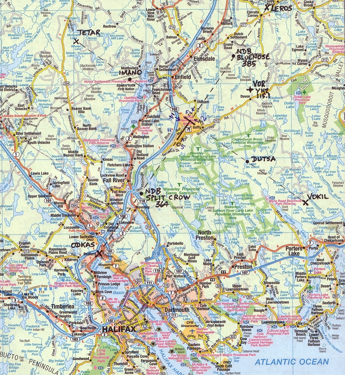
1. First, if you monitor Moncton Centre frequencies you will hear an expected aircraft first on one of those frequencies. By at least 100 nautical miles out from Halifax there will be a clearance to a lower altitude. At the boundary of the Halifax terminal area (35 nm) the aircraft will be transferred over to Halifax Terminal on 119.2. In the past, in peak arrival periods there has been use made of an additional frequency, 128.55 MHz; however this is not being heard in early 2010. Aircraft arriving and using IFR and a variety of types of navigation are directed to various approach points. This all depends on which runway will be used for landing. As you know this depends on the wind direction. At times there will be more than one runway possible and pilots will generally choose the one using less fuel, if traffic and descent allows. Two of the approach points are actual beacon locations, Split Crow [formerly Golf] (runway 05) and Bluenose [formerly Juliett] (runway 23). Others are imaginary spots around the airport, with the commonly used ones on the approaches to the the four runways. You will often hear the beacons and the approach fixes mentioned on the air, especially in poor weather conditions. Click here for a road map with the two beacons, the VOR and the six major approach fixes clearly marked. Here is another chart showing some of the fix locations.
2. By the area close to the airport the aircraft will be on 119.2 even if it started out on 128.55. If the pilot calls the field, i.e. indicates that he can see the field, he may be cleared for a visual approach to the designated runway. Sometimes, for practice, they will continue on instrument procedures even if the visibility is excellent. Please note that for instrument approaches there are standard procedures consisting of specified points and headings to reach the actual approach paths. These standard procedures are published in the Canada Air Pilot and vary according to the actual type of instruments being used. Some of these standard approaches are prefixed by names. For Halifax the most commonly heard prefix is "Fundy" but "Liscomb" is also heard quite frequently.
3. Once the aircraft is in the immediate vicinity of the airport (7 mile radius control zone) it is directed to switch to Tower on 118.4 and will eventually receive landing clearance. When touched down the controller will direct the pilot to exit the runway at a specified taxiway and to switch to the Ground Control frequency when off the runway.
4. The ground controller on 121.9 directs the aircraft to its gate or parking spot.
5. When the aircraft reaches the ramp it switches to 122.125 for ramp advisory and eventually reaches its destination.
Company Communications:
In addition to communications between controllers and aircraft there are also communications between the aircraft and the company's ground personnel. Nearing arrival there may be a check-in to verify gate location or special arrangements for passengers but much of this will be done long before arriving in the vicinity. On departure there are generally communications re load or fuel use. For the less prominent airlines the ground personnel are contracted and may serve other airlines as well. Additionally there are two FBO's (fixed base operations) that serve itinerant aircraft i.e. non-scheduled, that operate on 129.3 (Esso) and 123.4 (Shell). For company frequencies used for communications between ground and aircraft see my frequency list. Additionally there are ground communications systems at the airport using 400 MHz and perhaps also 800 MHz. I do not have these listed on my site but you can look up Westjet or Air Canada or the airport itself on TAFL.
In your own area of
the Maritimes there may be different frequencies but the procedures will be
essentially the same, though Halifax is more complex than any of the other
airports in the region.
UHF Aero Communications (Military Aero Band):
Please note that many
of these VHF frequencies in the Halifax area and throughout the Maritimes have
UHF equivalents for use by military aircraft. The military UHF aero band is
from 225 to 400 MHz and is not included in a lot of scanners. Occasionally you
will hear a VHF transmission to a military aircraft from a ground station and
not hear a reply, even in a local area. This usually means that the ground
station is simulcasting on its VHF and UHF frequencies and the military aircraft
is transmitting on the UHF frequency. By the way, military aircraft are just as
likely to be heard on the "civilian" VHF frequencies as they are on UHF.
Please note that the UHF band is also used for air to air communications. Most commonly this will be for US in-flight refueling that you may be surprised to know happens over Nova Scotia. I have included frequencies for this in my large frequency list accessed at the aero intro page.
If you are interested
in knowing more about aero communications or wish to see frequencies elsewhere
in Canada I suggest you go to the
Canadian Aeronautical Communications
Website.